
Season: Summer
One of the best hikes in Norway, the walk is about 21 km / 13 miles (6 - 7 hours), and is not as steep as the version with Bjørnstigen. You can enjoy waterfalls, rivers and the mountains on this hike.
To do the hike: Drive to Vassbygdi, and park your car there (Follow the sign that says Aurlandsdalen (When you get to Vassbygdi) to get to the parking). Take the morning bus to Østerbø and walk down to Vassbygdi (Skip Bjørnstigen on the way down). This trail is well marked.
Note: Bus only runs mid summer. Click here for the national Bus planner.
Overview
Type: A to B, Distance is not Accurate


Season: Late Spring - Fall
The small hike with a big view.
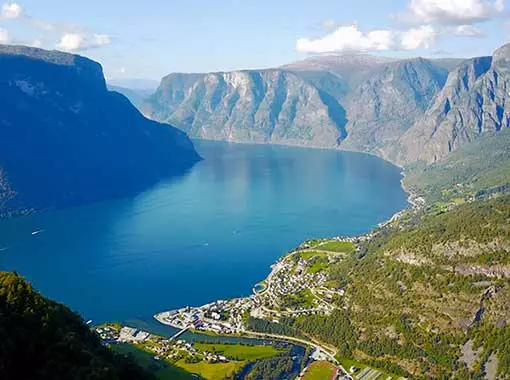
A truly magnificent view awaits you at Prest. This is a relatively small but steep hike that is only about 2 - 3 hours long (Roundtrip) if you start at the top parking.
To do the hike: Drive to the Prest parking lot (Drive to the Stegastein viewpoint and continue for another 2 kilometres after passing the viewpoint). The trail is easily visible from the parking lot. Hike to the top and take the same route back down.
Overview
Type: A to B to A

Season: Spring - Fall
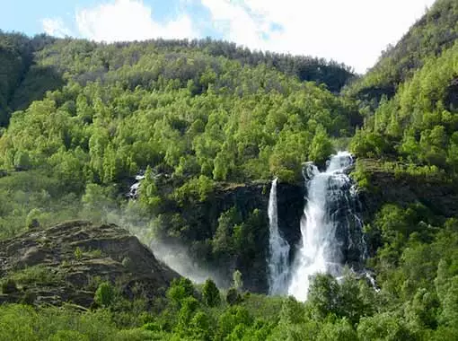
Small & beautiful hike.
Hike up to one of the great waterfalls you can see from the Flåm railway. This is a small, short and easy hike to do.
To do the hike: Start in Flåm centrum, walk up the valley and follow the map. The hike is very easy to do and very straight forward when you get started. You can also pick up a free hiking map at the Visitor Center in Flåm which features this hike.
Overview
Type: A to B to A, Distance is not Accurate


Season: Spring - Fall
A perfect walk for those who are not interested in climbing mountains and want a relaxed walk that is not too short. Half the walk will take you alongside the fjord and to the river at Volda. From Volda you will hike through the woods you will walk on the small local road back to Aurland. The hike only takes around 2 - 3 hours.
To do the hike: Start at Aurlandsvangen, follow the road following fjord (In the opposite direction of Otnes) till you get to a largely dried out river. Follow the sign to Bell and walk past Bell till you meet the road. Follow the road downwards till you end up at Aurlandsvangen again.
Overview
Type: Loop
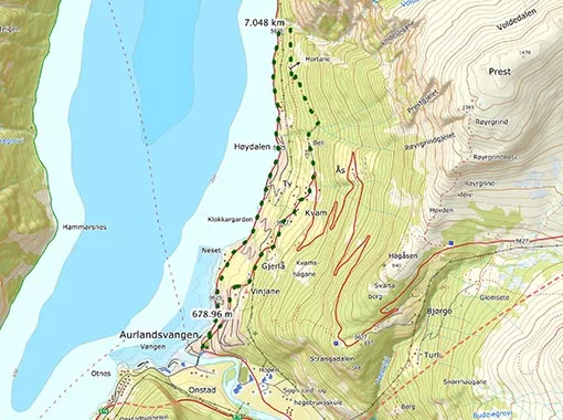
Hovdungo
Season: Spring- Fall
Hovdungo is located on the opposite side of the Stegastein viewpoint and offers a great view over the fjord. And you can start it at Otnes. The hike takes about 2,5 - 4 hours (Roundtrip).
To do the hike: Walk about 200 m / 650 ft (Direction towards Flåm) until you find the road that cuts up to the left. Follow that road to Li, and follow the half tractor road / half trail to Sele. Take the path to Hovdungo from Sele, take the same way back.
Overview
Type: A to B to A, Distance is not Accurate


Flåmsdalen
Season: Late Spring - Fall
The lighter alternative to Aurlandsdalen.
Walk alongside the famous Flåm railway and access parts such as Kårdalen by foot. Flåmsdalen is a great alternative to Aurlandsdalen, the hike is both shorter (4 - 6 hours, 20 km / 13 miles) and easier to do. You can also bike this.
To do the hike: Take the train from Flåm to Myrdal (Booking in advance is a must during spring, summer and early autmn) and follow the gravel path down to Flåm. The path turns into tarmac further down the valley, watch out for bikers and quad bikes, and when you get far down the valley; cars.
Overview
Type: A to B

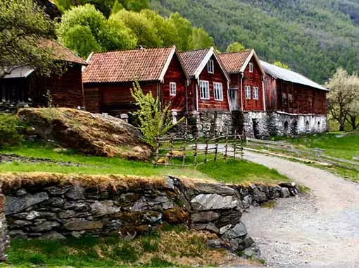
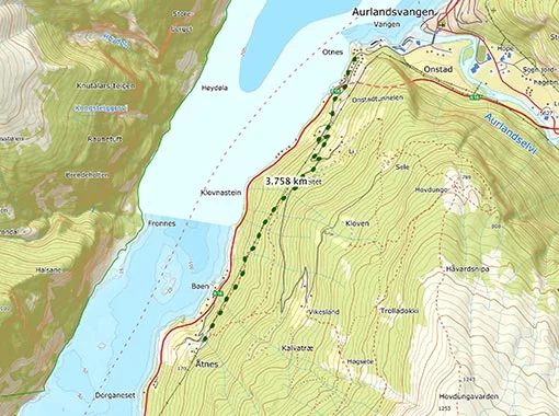
Otternes
Season: Spring- Fall
The hike from Otnes to Otternes is a perfect short and balanced hike (2 - 3 hours) you can do whenever you feel like. The hike takes you up Liavegen, giving you some nice views on the way. You get to walk a bit in the woods along the fjord with the highlight of the tour being the old farm of Otternes, which traces its history all the way back to the 17th century.
To do the hike: Walk about 200 m / 650 ft (Direction towards Flåm) until you find the road that cuts up to the left. Follow the windy road up until you find the sign that takes you to Otternes. Follow the trail until you find yourself at the farm of Otternes. Take the same way back.
Overview
Type: A to B to A, Distance is not Accurate
Are You Wondering About Something?
